Page 1 of 1
Help please identifying what these carved marks refer to.
Posted: Tue 08 Dec, 2015 9:43 pm
by Leodian
These carved marks caught my eye when I was passing today (Dec 8 2015) on Bishopgate. It states 2FT and has a bench mark like arrow beneath. The first photo is a close-up and the second shows the location at the left end of the black line that I managed to add to the across Bishopgate image (my photo editing skill and/or program I use is fairly basic).
It might be that the marks refers to a small nearby 'cover' on the pavement but if so it does not seem to be in the best place. I wonder if anyone knows or can suggest what the carved mark was/is for?
PS. I was surprised I even spotted the marks as they are not obvious. I really must though stop walking around with my eyes not looking straight ahead!
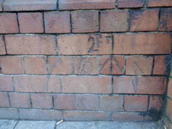
- Close-up of the carved marks on Bishopgate (taken Dec 8 2015).
- 533R.jpg (98.47 KiB) Viewed 10759 times
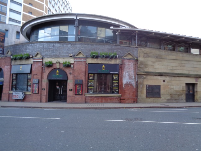
- The location of the marks at the left end of the black line in a view across Bishopgate (taken Dec 8 2015).
- 534R.jpg (103.65 KiB) Viewed 10759 times
Re: Help please identifying what these carved marks refer to.
Posted: Tue 08 Dec, 2015 11:58 pm
by blackprince
Re: Help please identifying what these carved marks refer to.
Posted: Wed 09 Dec, 2015 12:35 am
by Leodian
Thanks for your help blackprince.

I did not put the thread in the Cut Bench Mark (CBM) one as it does not seem definitely like a CBM and it also has a measure which I don't associate with bench marks. I had also looked at some maps (up to the early 1900s) in the Old Maps UK website and no bench mark is noted there. I don't though know how old the brickwork is, so the carved marks may be relatively modern.
Re: Help please identifying what these carved marks refer to.
Posted: Wed 09 Dec, 2015 10:23 am
by liits
I've seen measurements card into boundary / perimeter & outside walls before, although not in Leeds, and have found that they have been used to convey two different things;
Curtilage of the premises - the boundary of the land on which the property stands. More commonly this is now delineated by a line of studs set in the paving surface.
Subsurface extent of the property where control of any footway above has been ceded to another authority. ie it has a drain or more usually a cellar beneath the pavement. Much more common now is a sign attached to the wall stating that there is something beneath and these signs are generally placed when the Local Authority have implemented a scheme of re-paving and historic pavement lights [the glass block things] have been over paved.
Leodian's "2Ft" carving looks a lot older though so this is only supposition.
Re: Help please identifying what these carved marks refer to.
Posted: Wed 09 Dec, 2015 2:26 pm
by buffaloskinner
This building used to be the offices and transport club of the British Transport Police, so maybe it was for measuring the prisoners

Re: Help please identifying what these carved marks refer to.
Posted: Wed 09 Dec, 2015 2:46 pm
by warringtonrhino
If, for example, the ground level is raised an old benchmark could be obscured/buried
a new benchmark was introduced with a dimension to the old one.
Most bench marks have a carved symbol but not a level, you find the level on the OS map then add 2 feet.
Re: Help please identifying what these carved marks refer to.
Posted: Wed 09 Dec, 2015 7:52 pm
by Leodian
buffaloskinner wrote:This building used to be the offices and transport club of the British Transport Police, so maybe it was for measuring the prisoners
That made me
. The post also has one of the many things that I like about SL in that information is often given that I did not know, namely here that the "building used to be the offices and transport club of the British Transport Police".
Re: Help please identifying what these carved marks refer to.
Posted: Wed 09 Dec, 2015 11:09 pm
by dogduke
I frequented the BT police club during the 70's and 80's if I was working in Leeds.
I don't recall it being offices,BTP offices were in the signal box block which was opened
in the 60's after Leeds Central closed.
I can't recall there been any windows onto Bishopsgate street,the club was as you might expect
a bit dark inside.
Perhaps the markings are to do with the putting windows in?
Re: Help please identifying what these carved marks refer to.
Posted: Thu 10 Dec, 2015 9:47 pm
by Leodian
Thanks liits (and all for your help). Your post reminded me of a Great Northern Railway (G.N.R.) boundary mark I've seen on the former Wellesley Hotel building on Wellington Street. I've now found the thread about that mark that I started on Nov 23 2010 with a photo of it that I took then. This is the link to that thread
http://secretleeds.com/viewtopic.php?t=2889.
I however took the photos today (Dec 10 2015) that I've added here. The first is a close-up and the second shows its location at the former Wellesley Hotel just above ground level to the left of the glass double doors about in the centre of the photo and to the right of the two men.
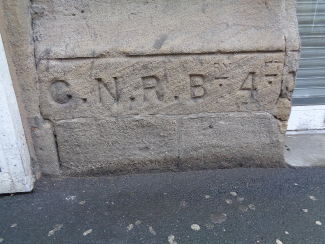
- Close-up of the G.N.R. Boundary marker at the former Wellesley Hotel on Wellington Street (taken Dec 10 2015).
- 568R.jpg (144.63 KiB) Viewed 10570 times
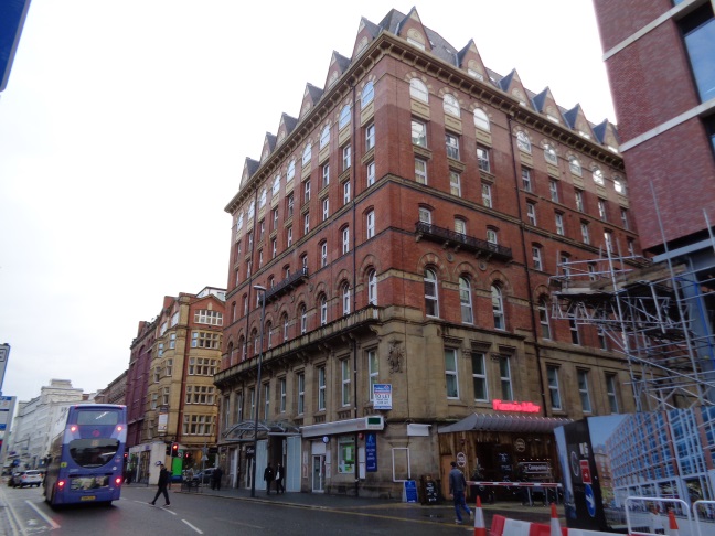
- View of the former Wellesley Hotel on Wellington Street (taken Dec 10 2015).
- 572R.jpg (128.55 KiB) Viewed 10570 times